
‘Going to Pakistan? With eight strangers, are you ok?’
‘Pakistan? Are you crazy or what?’
‘Going to Pakistan? Don’t you have better place to go?’
Those words were ringing in my ears as the ‘fasten your seat belt' light came on.
I stared out of the plane window blankly, wondering if it had been a mistake. I then turned around studying the expressions of those unfamiliar faces, wondering what was on their minds! Were they in the same predicament as me?
There were no answers to my questions, and there was no turning back!
I was on my way to northern Pakistan – to travel far and wide along part of the 1,300km long Karakoram Highway, or Friendship Highway as the Chinese call it.
We arrived at the Islamabad International Airport at 10.00pm. The hot summer heat of 40 degree C kept my enthusiasm burning, paralysing the initial doubt and uncertainty.
A 1-1/4-hour journey the next morning on a Fokker Friendship took us to a place called Gilgit, the administrative headquarters for the province of Northern Areas. This was the starting point of our 275km ‘epic’ journey along the Karakoram Highway. The highway, the name which seemed a misnomer to me, brought me lots of surprises and to places well beyond my wildest imagination.
Five days later, I stood at the border, one leg in Pakistan, and another, in China. The doubts and fear of: ‘Is this going to be a one-way journey?’, ‘Will I get killed in the supposedly hostile foreign land?’ dissipated like the early morning mist.
20080809


Islamabad / Rawalpindi
Although we landed at Islamabad International Airport, the airport is actually located in Rawalpindi (like our Kuala Lumpur International Airport which is located in Sepang).
 Hotel Blue Sky – our hotel in Rawalpindi
 Streets of Rawalpindi
Hotel Blue Sky – our hotel in RawalpindiStreets of RawalpindiGilgit
 Riveria Hotel – nice hotel with nice English-looking garden at the back
 Gilgit Bridge
 Someone had to give way. Who?
  Rock salt
 The crude and traditional way of crushing rock salt. (I hope I am right!)
 The crushed salt
 Gilgit River (opposite our hotel)
 Having soldiers around the town with guns was a common sight…
 …but this one?
Hunza River and the Old Silk Road
It was a long road to Karimabad, capital of Hunza, along the Karakoram Highway.
The highway, a joint venture project between Pakistan and China, was one of the biggest and most ambitious engineering projects in modern time. It took off in 1966. Although it was progressively opened to traffic, the entire highway, including Khunjerab Pass at Pakistan / China border, was opened to travellers only in May 1986.
The highway stretches and traverses across some of the highest and most treacherous mountain terrains and ranges – the Pamir and Karakoram ranges, starting from Havelian in Pakistan and ends in Kashgar, China.
Along this stretch of the highway, we came across the Asian Plate and the Indian Plate. ‘This is where the two plates collided…,’ our guide, Karim, explained as he pointed to the two mountains across the river.
We also travelled alongside the old silk road. Looking at it, I could imagine in my mind horses and donkeys treading along the route during the ancient time, kicking and sending the sand and dust flying, with the fragrance and aroma of the spices permeating the otherwise still air.
 Hunza River
 Asian Plate
 Indian Plate
 Part of the Old Silk Road (on the slope of the mountain)

The highway, a joint venture project between Pakistan and China, was one of the biggest and most ambitious engineering projects in modern time. It took off in 1966. Although it was progressively opened to traffic, the entire highway, including Khunjerab Pass at Pakistan / China border, was opened to travellers only in May 1986.
The highway stretches and traverses across some of the highest and most treacherous mountain terrains and ranges – the Pamir and Karakoram ranges, starting from Havelian in Pakistan and ends in Kashgar, China.
Along this stretch of the highway, we came across the Asian Plate and the Indian Plate. ‘This is where the two plates collided…,’ our guide, Karim, explained as he pointed to the two mountains across the river.
We also travelled alongside the old silk road. Looking at it, I could imagine in my mind horses and donkeys treading along the route during the ancient time, kicking and sending the sand and dust flying, with the fragrance and aroma of the spices permeating the otherwise still air.
Hunza RiverAsian PlateIndian PlatePart of the Old Silk Road (on the slope of the mountain)


Karimabad and Baltit Fort
Baltit Fort is the former palace of the Mirs (rulers) of Hunza until 1960. It is now a museum dedicated to the conservation of the Hunza people’s history and culture. It soars above the village of Karimabad, with Ultar Peak and its glacier as a curtain backdrop and commands a majestic view of Mt. Rakaposhi and Diran Peak (7,266m).


 Karimabad
 Karimabad
Hoper Glacier (2,900m)
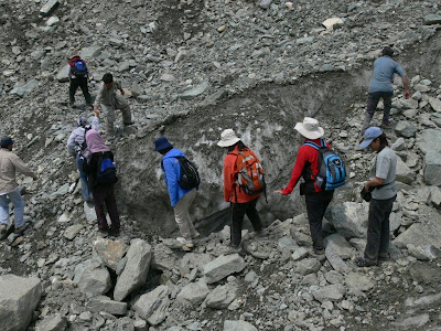
It took us about 40 minutes to walk from the top to the glacier. It was very steep and sandy at some locations.


 View from the top
 On the way…
 The glacier, getting closer
 Close-up view
 ‘We are here!’
 …returning
View from the topOn the way…The glacier, getting closerClose-up view‘We are here!’…returning Visitors’ Book
New day, new expectation! ‘What is in store for us today?’ I wondered to myself.
As we continued our journey along the Karakoram Highway, more surprises unfolded and more spectacular scenery greeted us.
We came across what is known as ‘visitors’ book’. They are stories carved out on rocks /stones and supposed to be common along the Karakoram Highway. We took the opportunity to get down from the van, took a walk along the highway and had a closer look at the carving.
 View taken near the hotel in Karimabad


As we continued our journey along the Karakoram Highway, more surprises unfolded and more spectacular scenery greeted us.
We came across what is known as ‘visitors’ book’. They are stories carved out on rocks /stones and supposed to be common along the Karakoram Highway. We took the opportunity to get down from the van, took a walk along the highway and had a closer look at the carving.
View taken near the hotel in Karimabad Taking a walk along the highway
Upper Hunza Area
Hunza Valley (2,438m): the original Shangri-la?
The valley is popularly believed to be the inspiration for the mythical valley of Shangri-la in James Hilton's 1933 novel, Lost Horizon and it is believed that the people of the valley used to live until the ripe old age.
The valley is popularly believed to be the inspiration for the mythical valley of Shangri-la in James Hilton's 1933 novel, Lost Horizon and it is believed that the people of the valley used to live until the ripe old age.

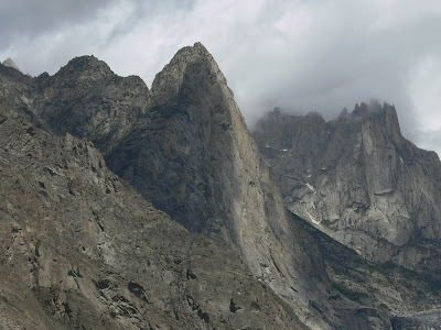

 Chamangul white glacier
Al Amyn Model School, Gulmit
We were invited to attend Parent’s Day / Prize Giving Day celebration at Al Amyn Model School in Gulmit. There were some interesting presentations by the students and two of our members were invited to give away prizes. We also walked around the school ‘popping’ in and out of the classrooms while classes were going on. Perhaps that was the first time they ever had foreign visitors.
Two days later, we went back to present some tokens to the school – books, food stuff and money. It was an eventful and meaningful visits.
Two days later, we went back to present some tokens to the school – books, food stuff and money. It was an eventful and meaningful visits.


 Full of concentration


 Students’ creation
 Outside the school
Subscribe to:
Posts (Atom)